
Latest Version
Version
4.20.4
4.20.4
Update
December 10, 2025
December 10, 2025
Developer
p-lr
p-lr
Categories
Travel & Local
Travel & Local
Platforms
Android
Android
Downloads
0
0
License
Free
Free
Package Name
com.peterlaurence.trekme
com.peterlaurence.trekme
Report
Report a Problem
Report a Problem
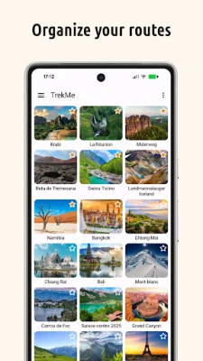
More About TrekMe - GPS trekking offline
Explore the wilderness without limits.
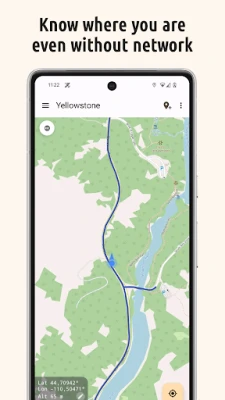
TrekMe turns your phone into a reliable, offline GPS navigator. Whether you are trekking, biking, or mountaineering, get your live position on topographic maps. Download the maps you need, and then navigate without an internet connection.
🔒 100% Privacy Oriented
We believe your location is your business. TrekMe features zero tracking. Your data never leaves your device, and you are the only one who knows where you go.
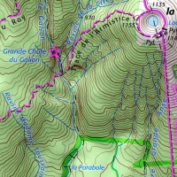
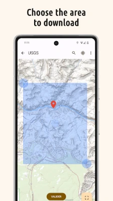
🌍 Download Offline Maps
Create your own maps by selecting the area you need. Once downloaded, they are available completely offline—perfect for dead zones.
• Supported Sources: USGS, OpenStreetMap, SwissTopo, IGN (France and Spain).
• Storage Friendly: Save heavy maps to your SD card to free up internal memory.
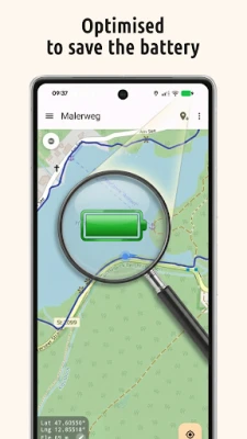
🔋 Built for Endurance
Don't worry about your battery dying mid-hike. TrekMe is engineered for efficiency, ensuring fluid performance with ultra-low battery usage.
Key Features
• 📍 Navigation: View your live position, orientation, and speed.
• 👣 GPX Manager: Import, record, and share tracks in GPX format.
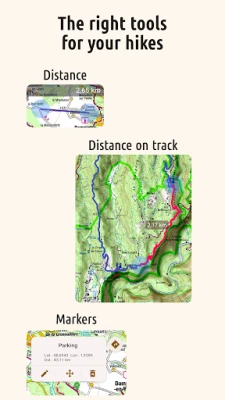
• 📈 Real-time Stats: Visualize distance, elevation, and speed while recording.
• 🖍️ Markers: Add POIs (Points of Interest) with comments and photos on the map.
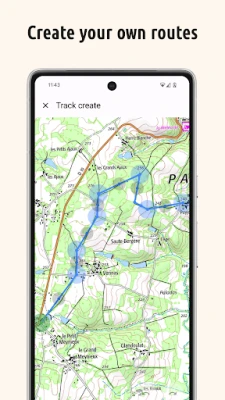
• 📏 Planning: Create tracks manually and measure distances between points.
🚀 Unlock Premium
Take your adventure further with advanced tools:
• Safety Alerts: Get notified when you stray from your track or approach specific locations.
• Unlimited Maps: No size limits for map downloads.
• Pro Tools: Edit tracks (split/merge), fix missing map tiles, and access HD OpenStreetMaps.
• Organize Limitlessly: Create unlimited folders to perfectly structure and manage all your recorded tracks.
• Official French Topo Maps: Access the gold standard for hiking in France (IGN).
📡 For Professionals & Enthusiasts
Need high-precision data? Connect an external Bluetooth GPS(*) to TrekMe.
• Bypass internal GPS for higher accuracy.
• Ideal for aeronautics, professional topography, and high-frequency location updates.
(*) Supports NMEA over Bluetooth
User Guide & Support
https://github.com/peterLaurence/TrekMe/blob/master/Readme.md
🔒 100% Privacy Oriented
We believe your location is your business. TrekMe features zero tracking. Your data never leaves your device, and you are the only one who knows where you go.
🌍 Download Offline Maps
Create your own maps by selecting the area you need. Once downloaded, they are available completely offline—perfect for dead zones.
• Supported Sources: USGS, OpenStreetMap, SwissTopo, IGN (France and Spain).
• Storage Friendly: Save heavy maps to your SD card to free up internal memory.
🔋 Built for Endurance
Don't worry about your battery dying mid-hike. TrekMe is engineered for efficiency, ensuring fluid performance with ultra-low battery usage.
Key Features
• 📍 Navigation: View your live position, orientation, and speed.
• 👣 GPX Manager: Import, record, and share tracks in GPX format.
• 📈 Real-time Stats: Visualize distance, elevation, and speed while recording.
• 🖍️ Markers: Add POIs (Points of Interest) with comments and photos on the map.
• 📏 Planning: Create tracks manually and measure distances between points.
🚀 Unlock Premium
Take your adventure further with advanced tools:
• Safety Alerts: Get notified when you stray from your track or approach specific locations.
• Unlimited Maps: No size limits for map downloads.
• Pro Tools: Edit tracks (split/merge), fix missing map tiles, and access HD OpenStreetMaps.
• Organize Limitlessly: Create unlimited folders to perfectly structure and manage all your recorded tracks.
• Official French Topo Maps: Access the gold standard for hiking in France (IGN).
📡 For Professionals & Enthusiasts
Need high-precision data? Connect an external Bluetooth GPS(*) to TrekMe.
• Bypass internal GPS for higher accuracy.
• Ideal for aeronautics, professional topography, and high-frequency location updates.
(*) Supports NMEA over Bluetooth
User Guide & Support
https://github.com/peterLaurence/TrekMe/blob/master/Readme.md
Rate the App
Add Comment & Review
User Reviews
Based on 0 reviews
No reviews added yet.
Comments will not be approved to be posted if they are SPAM, abusive, off-topic, use profanity, contain a personal attack, or promote hate of any kind.


More »

Popular Apps

Yahoo MailYahoo

Offline Games - No Wifi GamesJindoBlu

Photo Prints Now: CVS PhotoPrint Photos - 1 Hr Phone Printing

Ground DrillerFevergames inc

Grounds and GraceCraver Solutions

Yea!Co-operative Bank of Kenya Ltd

MeChat - Interactive StoriesPlayMe Studio

Cash Rally - Slots Casino GameSpinX Games Limited

LWMLYourGiving, Inc

Ludo King®Gametion
More »
Editor's Choice

Raid Rush: Tower Defense TDPanteon

Galaxy Defense: Fortress TDCyberJoy Games

ArriveCANCBSA-ASFC

Modern Combat 5: mobile FPSGameloft SE

Modern Strike Online: War GameAzur Interactive Games Limited

AI Journal Notebook - ReflectrDaily Labs, LLC

Reflection FrameCreative Design Worx

Wayfair - Shop All Things HomeWayfair, LLC

GS KING RELOADGS King Reload

GSPlusGalatasaray SK